
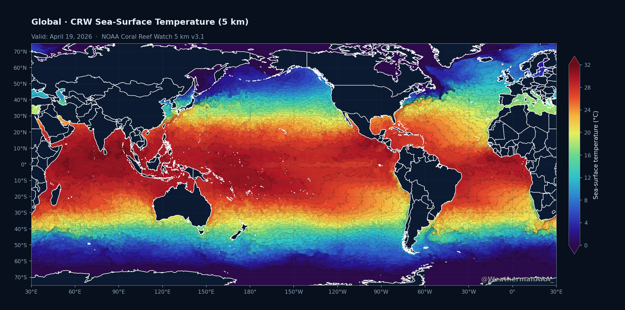
Global actual sea-surface temperature.
Daily ocean-temperature maps from three NOAA products: OISST v2.1 (0.25°), Coral Reef Watch (5 km), and AOML's TCHP + D26 subsurface heat analysis (0.25°). Pick a region and variant in any section. Updated once per day.
NOAA OISST v2.1 daily analysis. Anomalies computed vs the 1991–2020 climatology; records compared against the full OISST era (1982-present).
Loading latest valid date…
Higher-resolution SST from NOAA's Coral Reef Watch v3.1 analysis (0.05° grid). Anomalies are computed here against the 1991–2020 daily climatology so the CRW and OISST panes use a matching baseline.
Loading latest valid date…
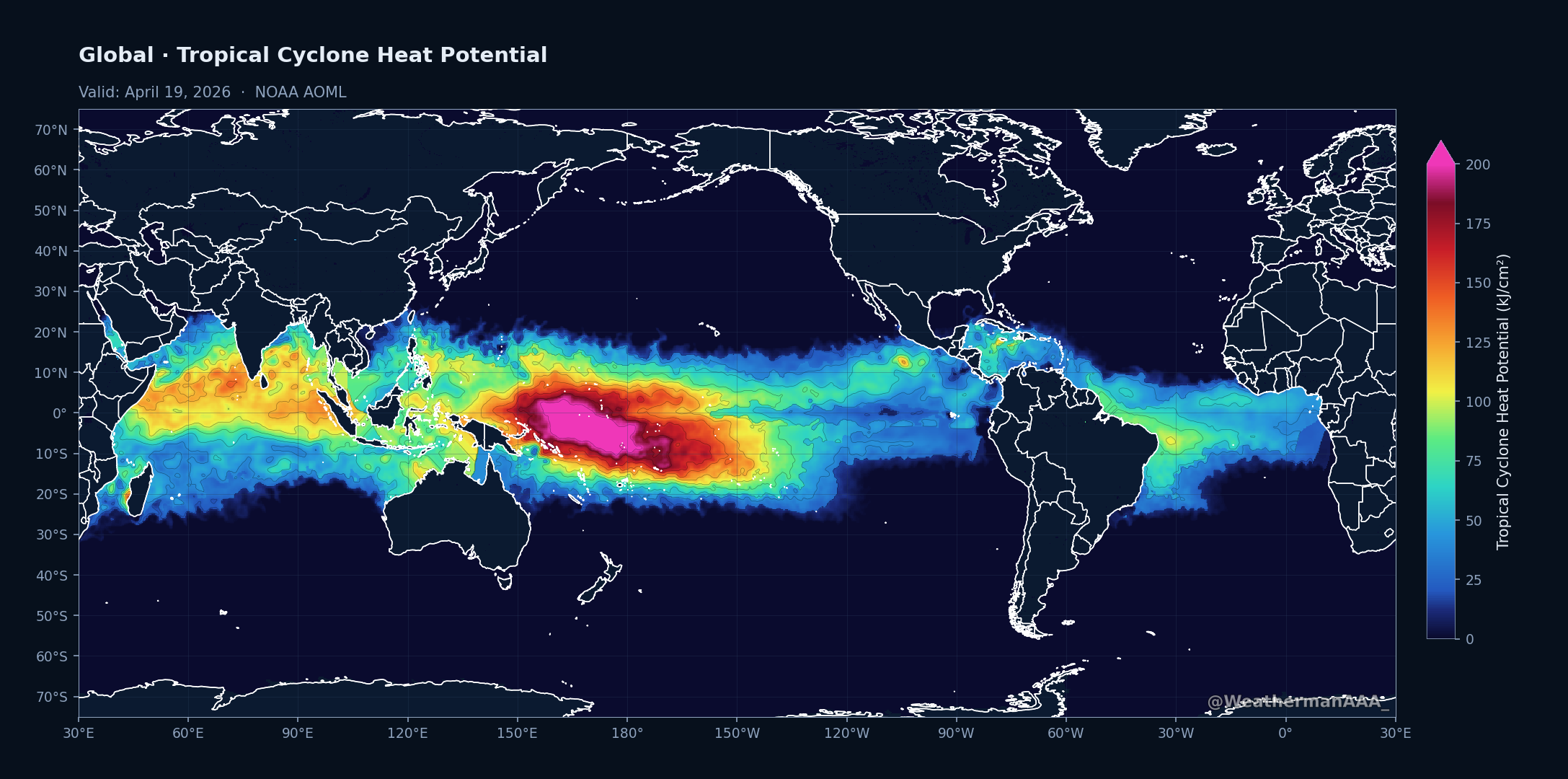
Tropical Cyclone Heat Potential (TCHP) and 26 °C isotherm depth (D26) from two independent analyses. NOAA AOML updates daily with ~1-day latency (2022-present archive, no anomalies). Copernicus Marine ARMOR3D updates weekly with ~1-week latency, back to 1993, and supports anomalies vs. a 1993–2020 climatology. Use the source toggle to switch between them.
Loading latest valid date…
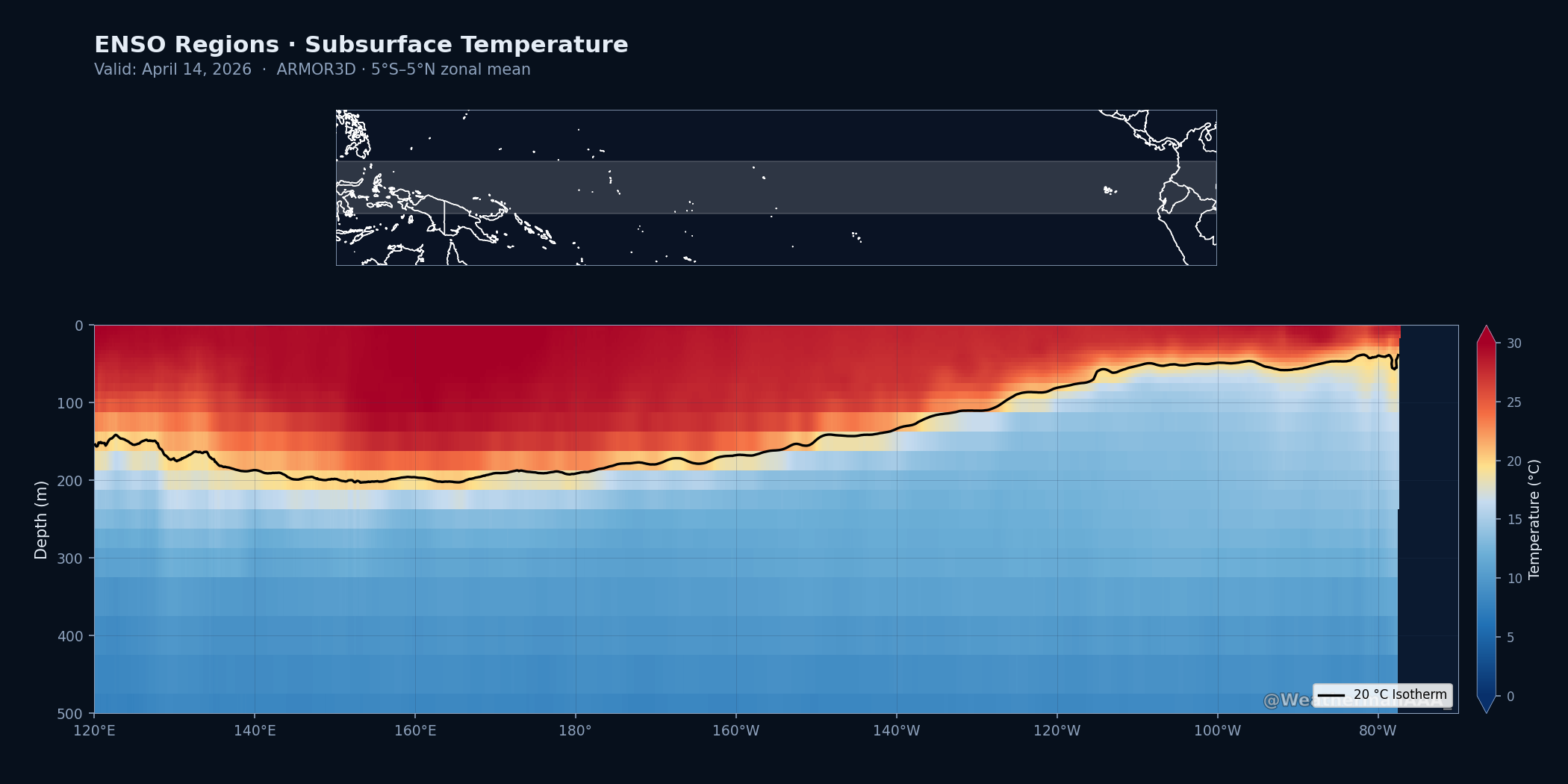
Longitude-by-depth slices of the ocean's upper 500 m. The fill shows temperature anomaly vs. the 1993–2020 weekly climatology (when available); the solid black line is the current 20 °C isotherm, and the dashed black line is that isotherm's climatological position. Deep warm anomalies below the isotherm are the subsurface signature of ENSO, Atlantic Niño, and IOD events.
Actual shows each grid cell's sea-surface temperature on the latest analysis day, colored from violet (cold, 0 °C) through blue, green, yellow, orange, and red (warm, 32 °C). Contour lines run at each integer degree for easy reference.
Anomaly shows how today's SST compares to the 1991–2020 mean for this same day of year. Red / magenta tones mark areas warmer than average; blue / purple mark cooler. Scale runs from −5 °C to +5 °C; values beyond saturate at the extremes.
Anomaly + Records overlays diagonal hatching and a black outline on the anomaly map where today's SST is the warmest or coldest ever observed for this day of year since OISST records began in 1982. The underlying color tells you the direction: red-hatched = record high, blue-hatched = record low.
TCHP (Tropical Cyclone Heat Potential, kJ/cm²) is the integrated heat content of the upper ocean column down to the 26 °C isotherm, effectively how much warm water is available to fuel a passing tropical cyclone before its own wind-driven mixing reaches cooler water. Operational thresholds commonly cited: 16 kJ/cm² to sustain a TC, 60 for development, 100 for intensification, 125 for rapid intensification, 160+ for explosive deepening into high-end hurricanes.
D26 is the depth of the 26 °C isotherm in meters, i.e. how thick the warm-water "blanket" is. Shallow D26 (under 30 m) means even a modest TC can mix enough cold water up to cap its own intensity. Deep D26 (100 m+) is why the Gulf of Mexico's Loop Current, the Western Atlantic warm pool, and parts of the West Pacific can support rapid intensification.
TCHP Anomaly (ARMOR3D only) compares this week's TCHP to the 1993–2020 mean for the same week of the year. Reds indicate more heat content than normal (favorable for intensifying TCs); blues indicate less. The long ARMOR3D archive makes a stable 28-year climatology possible, which the 2022-present AOML record is still too short to support.
Equatorial cross-sections (ARMOR3D only) average temperature over the 5°S–5°N band and plot it as longitude × depth. The black 20 °C isotherm is the canonical diagnostic.
SST fields come from NOAA's OISST v2.1 (0.25° daily, 1982-present) and Coral Reef Watch CoralTemp v3.1 (5 km daily, 1985-present). Subsurface fields come from two sources: NOAA AOML PhOD's TCHP/D26 analysis (0.25° daily, 2022-present, no anomaly), which blends altimeter sea-surface height anomalies with microwave SST to estimate the vertical thermal structure; and Copernicus Marine ARMOR3D L4 (0.25° weekly, 1993-present), a 3D ocean temperature + salinity analysis from which we derive TCHP + D26 on the fly and compute anomalies vs. the 1993–2020 mean. AOML maps refresh daily; ARMOR3D maps refresh weekly (Thursdays).